
Stereonet Charts
To access this screen:
-
Display the Plots window and select the Manage ribbon.
-
Select Sheets >> Charts >> Stereonet.
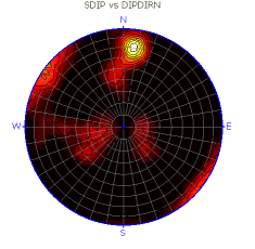
Stereonet Charts are an essential tool for the analysis of geological structure data and its application in mine planning and production. The main function of a stereonet is to determine geological structure trends and their relationship to excavation surface orientations. This can be a statistical analysis that identifies whether the data is random or has a preferred orientation. Data distributions can also indicate key structural issues.
The main applications for Stereonet Charts are:
-
Structural analysis of joint and fault data.
-
Pit bench and slope stability analysis.
-
Underground excavation stability analysis.
-
Blast pattern optimisation.
Stereonet Charts can use spatial 3D structural data. See Structural Data for information about sourcing and formatting structural data. General structural trends can be determined, and individual poles or planes in the stereonet can be linked to specific points in 3D space in the Design and VR windows.
What is a Stereonet?
A stereonet, also known as a stereogram or hemispherical projection, represents the orientation of 3D structure data on a 2D surface. This data is represented by dip direction and dip. In a stereographic projection, planes and lines are drawn as they would appear if they intersected the bottom or top of a transparent sphere viewed from above.
The grid lines on a stereonet plot show the projection of a set of great circles and a set of small circles that are perpendicular to one another. They are similar to longitude and latitude lines on a globe. These grid lines can be used to locate the orientation of planes and lines. The following image shows an equal-area stereonet with the positions of the Dip Direction and Dip grid lines.
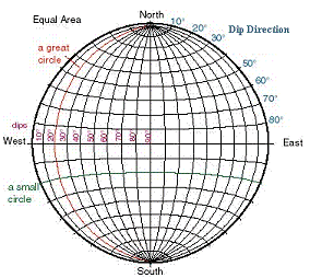
There are two key guide structures on a stereonet diagram:
-
Great circles - A circle on the surface of a sphere made by the intersection with the sphere of a plane that passes through the centre of the sphere and through both the north and south poles. The longitude lines on a globe are great circles. In the previous diagram, the great circle is shown as a red line.
-
Small circles - A circle on the surface of a sphere made by the intersection of a plane that does not pass through the centre of the sphere. In a stereonet, small circles are perpendicular to the orientation of the great circles. The latitude lines on a globe are small circles. In the previous diagram, the small circle is shown as a green line.
Note: The latitude and longitude lines on a globe are perpendicular to each other. A lower hemisphere stereonet projection should be visualised as the bottom or top half of a sphere. Planes intersect the sphere as great circles, and lines intersect the sphere as points.
Structural Features on a Stereonet
Two broad types of structural features can be plotted on a stereonet:
-
Lines - Trend and plunge features, such as slickenside lineation, fold axes, and underground drive axes.
-
Planes - Dip direction and dip features, such as fault planes, pit benches or slopes, and underground excavation surfaces.
On a stereonet plot:
-
A line plots as a point.
-
A plane plots as a great circle, a point, or both. The point is referred to as the pole and is perpendicular to its associated plane.
All plotted elements pass through the centre of the hemisphere. Their projection reflects where the plane or line intersects the outer hemispheric surface. This means the plot represents relative orientation, not relative position.
A stereonet is used to:
-
Plot individual or average structural feature orientation, often expressed as a data cloud with dispersion around an average value.
-
Find the intersection between two planes, such as the surfaces of a rock wedge or the relationship between a structural feature and an excavation surface.
-
Find the angle between two lines, two planes, or a line and a plane.
Stereonet Example
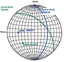
The following diagram shows two planes, each represented by great circles and poles. The green plane has an orientation of 045/50, which is dip direction/dip. The blue plane has an orientation of 090/50.
For worked examples, see Stereonet Analysis - Exercises and Slope Failure Mode Analysis.
Stereonet Charting
The following key features are available with Stereonet Charting:
-
Generate single or multiple stereonet plots on key data fields.
-
Generate stereonet plots for external files and loaded data.
-
Link stereonet plot data dynamically with loaded 3D structure feature data in 3D windows.
-
Output stereonet charts for use in presentations and reports.
-
Use lower and upper hemisphere projections.
-
Use Wulff or Schmidt projection methods.
-
Add sets, planes, and cones for use in structure analysis and mine planning.
-
Generate summary statistics for sets of features.